Mapping the Underground

Written by Pam Preedy.

On the 10th January, 1863 the Metropolitan Railway Company opened the first urban underground railway in the world. It ran from Paddington to Farringdon via six intermediate stations, using a steam locomotive. By 2024 there were 272 stations on eleven different lines stretching into the London’s suburbs as far as Amersham, Uxbridge and the five Heathrow Terminals to the west; Richmond, Wimbledon, and Morden to the south; Upminster to the east and Epping, Cockfosters, High Barnet and Watford to the north. The question is; how to produce a map of such disparate places that travellers can easily find their way about. The tube system expanded to the north and west because that was where the stations were needed. Furthermore soft clay spoil was perfect for Tube tunnelling in the north and west. The ground was much harder in the south.

The earliest underground railways were built by digging down from ground level and over- filling the top. The trains were steam railways. By 1870 technology had led to safer and deeper tunnelling with later electric power and safe lifts by 1880. But it was not until 1906-7, with money raised by an American financier, that the core of the modern Tube system was completed.

The next conundrum was creating a map of the underground. There have been some twelve generations of the tube map. The first two (1895 – 1st-5th versions and 1908)1 were geographic maps of London overlaid with the underground lines. It showed where passengers were in relation to the streets above and gave ’tourist’ information for example linking the stations to the timetables for horse-drawn buses.

In 1933 Harry Beck, a draughtsman working for the underground, supported by his wife, Nora, produced the now familiar diagrammatic tube map, inspired by an electrical circuit diagram. In 1931 he had been laid off by the Signalling Department of The Underground Electric Railways of London. While he was off work he became obsessed with how to map the tube. By then the underground (tube) had developed a dense central area, which was enlarged in relation to the outlying areas. To enable both to be shown more clearly, he developed a non-geographic linear diagram. In most cases it showed straight horizontal lines, right angular crossings and equalising the distances between stations. When Beck first presented his map to Frank Pick of the London Underground; the design was rejected, Pick wanted a more geographic design and worried about the distance between the stations. It seems that they held Beck in low regard because he was an engineer. Beck, therefore, printed and presented a trial run of 500 copies of his map and distributed at a few select stations. A positive reaction from customers proved it a sound design and in 1933 700,000 copies were distributed. It was so successful that within a month a large reprint was required.

There are anomalies on the maps for purists who would like the underground map to be more geographically exact. I certainly got into trouble some years ago when I wanted to go from King’s Cross to the Angel. It didn’t look too far on the underground map, so I decided to walk above ground. The distance was far longer than I expected – I regretted my decision. There are ghost stations; that were built, but never opened and other disused stations no longer open to passengers, but still exist underground.

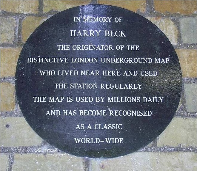
Henry got little thanks for his efforts. He received little thanks or recognition for his work He was never formally commissioned to develop his ideas and worked on his map in his spare time. He was never paid though some reports suggest he was paid a fee of five or ten guineas. He died in 1974 and was finally recognised posthumously in the 1990s with the Beck Gallery at the London Transport Museum and in 2003 with a blue plaque at Finchley Central Underground Station.

For a complete set of underground maps, look at the following website:
www.ltmuseum.co.uk/collections/stories/design/mapping-london-iconic-tube-map


Originally published in Life in Bromley magazine 

Share this: